Radar image credit: ESA SEOM InSARap study. Contains Copernicus data (2015)
Stephen Hicks is studying for a PhD in Earthquake Seismology at the University’s School of Environmental Sciences and is part of Professor Andreas Rietbrock’s research group.
“We have all been moved by the shocking images and videos that have come out in the aftermath of the magnitude 7.8 Nepal earthquake. The official death toll could rise close to 10,000, although one earthquake hazard expert has put the estimate closer to 40-60k.
The remotest villages at the centre of the earthquake’s rupture are only now starting to be scoured by search and rescue teams.
The Nepal earthquake has highlighted the massive forces acting between the broken up parts of Earth’s crust – tectonic plates.
This earthquake occurred right at the front line of a titanic collision between the Indian plate and the Eurasian plate -responsible for Earth’s tallest mountain range – the Himalayas.
This coming together of plates has been happening for the past 40 million years and is causing India to slide slowly under the Himalayas and the Tibetan plateau.
Although the speed of this collision is only around as fast as the growth of our fingernails, the two plates can be stuck against each other for hundreds of years and the stresses that have been building up over this time can be suddenly released in large earthquakes such as what we have just seen in Nepal.
Looking for answers
Earthquake scientists across the globe are now scouring available geophysical data for answers. In the short term, we need to know which areas of Nepal were damaged the most in the earthquake.
However, there are many other regions of the Himalaya that could be at risk of a large earthquake in the future.
Importantly, we need to know whether the earthquake completely released all the built-up stress beneath central Nepal.
Once the primary search & rescue and aid efforts come to a close, we will need to find out what the Nepal earthquake means for the areas directly west and east of the rupture and for the Himalaya as a whole.
Scientists do not currently know the maximum possible depth of earthquake ruptures along the fault beneath the Himalayas. This is important to understand as it is one control on the maximum possible magnitude of earthquakes. Studying the Nepal earthquake could shed light on this issue.
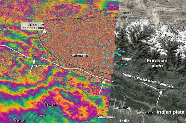
Satellite data from the European Space Agency’s brand new Sentinel-1 satellite is giving the earthquake science community an unprecedented view of the Nepal quake.
Preliminary analysis
Preliminary analysis has shown that the area of fault that moved was 120 x 100 km – an area around the same size as the entire northwest of England.
The fault moved the most (around 5 m) beneath Kathmandu. The villages in the surrounding foothills will be very susceptible to damaging landslides. Landslides can sometimes be just as fatal as the earthquake shaking alone.
Although scientists had known that Nepal was a region of high seismic hazard, we are not yet at the stage where we can predict exactly when an earthquake will occur and when.
Improved modelling on supercomputers combined with dense observations on the ground and from satellites can better help us to quantify seismic hazard in different areas and for different earthquake scenarios.”